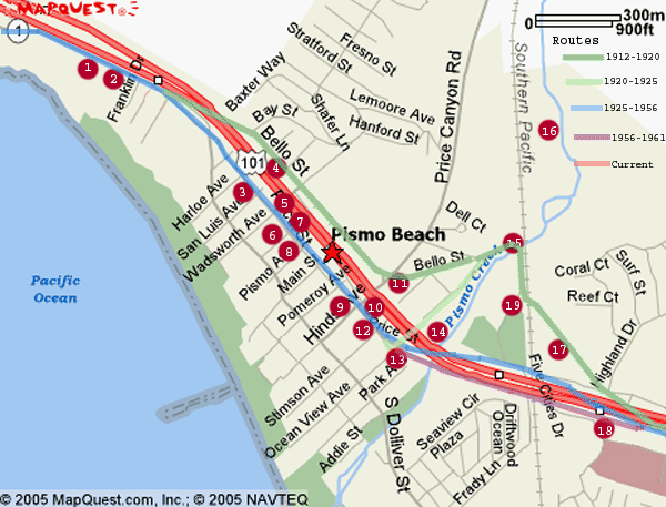
Pismo Beach Section
The locations in the Pismo Beach section are numbered from south to north starting at the 5 cities drive exit from the current freeway, near the large Factory Outlets. North from there, the routings of 101 became very difficult and complicated to discover, but thanks to some very helpful folks at the Pismo Beach city hall, the SLO County Historical Society, and to local historian Effie McDermott, I was able to put together the history of the various routings, and details of the old 101 through this historic area. Including the present freeway, there have been five different routing changes on the highway through Pismo Beach since 1912. The original county road, and later designated Route 2 in 1912 as you come in from the south, angles NW and made a uncontrolled dirt crossing over the SP railroad tracks before crossing a steel bridge over Pismo Creek that was built in 1912. From there it moved north on what is now Bello St all the way through Pismo Beach and merged with the current Price Street just north of town. In 1925 it was routed from just north of the 1912 bridge SW on Ocean View avenue to Price St. where it made a hard right turn, and continued north through town. Beginning in 1925 or 1926, just after being designated 101, two bridges and an elevated section were built at the south end of town to carry traffic over the SP tracks, Pismo Creek, and smooth out the hard turn at Ocean View avenue. The route stayed there until 1956 when construction began on widening the 101 to 4 lanes. For a brief period between 1956 to 1961, a bridge was constructed near Park St. over Pismo Creek to handle traffic during construction. This was later altered, and converted to a southbound onramp from Price St. to the current feeway.

Location # |
Thumbnail |
Description |
1912
Steele Bridge (Panoramic) |
||
Comments, suggestions, and feedback are welcome
E-mail
me at: don@Historic101.com


